Headwall Photonics Co-Aligned VNIR-SWIR Sensor with LiDAR
Introduction
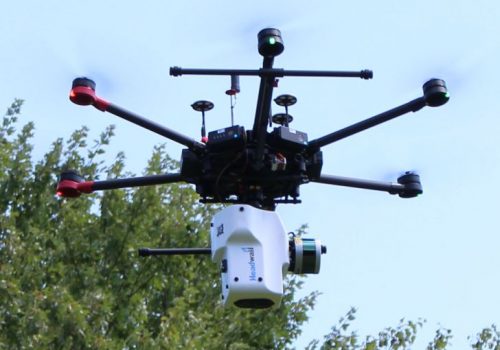
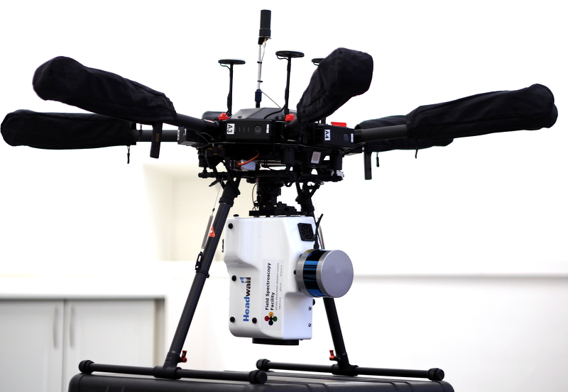
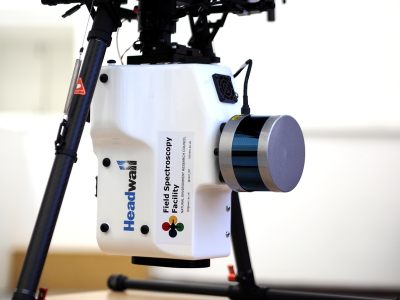
The Headwall Co-Aligned VNIR-SWIR and LiDAR UAV mounted sensor is a class - leading hyperspectral pushbroom imager, capable of superb spectral and spatial resolution. This system is the first of its kind in Europe, and the first to be made openly available to researchers.
This system provides high spatial resolution (c. 5cm GSD), 3D projected, full-range hyperspectral imagery to support a wide range of applications, including mapping and monitoring of: vegetation, plant species, biodiversity, biomass, stress indicators, disease, agriculture, geology and many more. The attached 16 channel LiDAR allows orthorectification of flight lines over complex terrain and fusion with the hyperspectral datacube for three dimensional representation of spectral data and integration of LiDAR-based biomass estimates with different spectral products.
This sensor is available to all NERC grants, with FSF covering flight and operation of the sensor, as well as processing of the data to surface reflectance. Please contact us at least one month prior to your application deadline to discuss your project. We will then ask you to fill out a form outlining your proposal. This allows us to make a decision about the suitablilty of the system and the chosen research location to the Headwall system.
Direct access loans are also available, please contact us to discuss your requirements.
Features
The Headwall Co-Aligned system is mounted on a DJI M600 Pro. The system can achieve data acquisition times of ~15minutes. Area covered is dependent on the spatial resolution and spectral resolution required by the end user, and lighting conditions.
Example Conditions
|
Fine Resolution |
|
|
Ground Sampling Resolution |
30mm |
|
Acre/Battery Set |
8 |
|
Flight Time |
15mins |
|
Medium resolution |
|
|
Ground Sampling Resolution |
60mm |
|
Acre/ Battery Set |
17 |
|
Flight Time |
15mins |
FSF has significant battery capacity, and can accommodate multiple flights. Details of your flight requirements will take place during your loan assessment, and if successful, during your training with the FSF.
Specifications
|
HEADWALL PHOTONICS HYPERSPEC CO-ALIGNED VNIR-SWIR SENSOR |
||||
|
|
||||
|
DUAL-SENSOR |
||||
|
SPECTRAL RANGE |
VNIR (400-1000NM) |
SWIR (900-2500nm) |
||
|
SPECTROGRAPH DESIGN |
High throughput aberration-corrected concentric imager |
|||
|
Spectral Pixels |
270 |
267 |
||
|
Spatial Pixels |
640 |
|||
|
Detector Pixel Pitch |
7.4 microns |
15 microns |
||
|
Dispersion per Pixel |
2.2 nm/pixel |
6nm/pixel |
||
|
FWHM Slit Image (nm) |
6 |
10 |
||
|
f/# |
2.5 |
|||
|
Slit & Grating |
20 microns x 6 mm, holographic |
10.4mm x 25 mirons, Diamond turned |
||
|
Grating Efficiency |
0.275 Normalised |
0.74 Normalised |
||
|
Residual Smile (microns) |
<1.5 |
1.4 |
||
|
Residual Keystone (microns) |
<1.5 |
1.8 |
||
|
Sensor Technology |
CMOS |
Stirling-cooled MCT |
||
|
Max Frame Rate (Hz) |
350 |
200 |
||
|
Bit Depth |
12 |
16 |
||
|
Shutter |
Global |
|||
|
Spatial Resolution |
3cm at 50m AGL |
|||
|
Size |
272mm x 208mm x 165mm |
|||
|
Weight |
Instrument: 4.8kg All up weight: 14.8kg |
|||
|
Power Consumption |
26W |
|||
|
Storage |
480GB, GigE Connection |
|||
|
Operating Window |
<80%RH non-condensing, 0-40oC |
|||
|
LIDAR |
16 channel Velodyne Puck LITE ™ |
Gimbal |
Fixed Mount |
|
|
GPS |
Trimble Applanix APX-15
|
GPS Details |
PPK, 2cm accuracy |
|
|
|
|
|
|
|


Privacy Notice Accessibility Notice